The Python based solid Earth tides (PySolid) is a thin Python wrapper of the solid.for program (by Dennis Milbert based on dehanttideinelMJD.f from V. Dehant, S. Mathews, J. Gipson and C. Bruyninx) to calculate solid Earth tides in east/north/up direction (section 7.1.1 in the 2010 IERS Conventions). Solid Earth tides introduces very long spatial wavelength range components in SAR/InSAR observations, as shown in the Sentinel-1 data with regular acquisitions and large swaths (Fattahi et al., 2020).
This is research code provided to you "as is" with NO WARRANTIES OF CORRECTNESS. Use at your own risk.
PySolid relies on a few Python modules as described in requirements.txt and compilation of the Fortran code.
We maintain a few pre-compiled version of the Fortran code, so that one could install PySolid via pip as below, without the fortran compiler and manual compilation. However, this works for recent numpy versions on macOS and Linux only.
# use "pip install --upgrade" to update to the latest version
pip install git+https://github.com/insarlab/PySolid.gitBelow is example of using conda to compile from source:
# download source code
cd ~/tools
git clone https://github.com/insarlab/PySolid.git

# install dependencies via conda
conda install -c conda-forge --file PySolid/requirements.txt

# compile the Fortran code into a Python interface using f2py to generate the C extension files, e.g.:
# solid.cpython-37m-darwin.so           for macOS
# solid.cpython-37m-x86_64-linux-gnu.so for Linux
cd ~/tools/PySolid/pysolid
f2py -c -m solid solid.for
Set the following environment variable (e.g. in ~/.bash_profile for bash users or ~/.cshrc for csh/tcsh users).
export PYTHONPATH=${PYTHONPATH}:~/tools/PySolidTo test the installation, run the following:
python -c "import pysolid; print(pysolid.__version__)"
python ~/tools/PySolid/tests/test_SET_grid.py
python ~/tools/PySolid/tests/test_SET_point.pyPySolid could compute solid Earth tides in two modes: point and grid. Both modes produce displacement in east, north and up direction.
- Point mode: compute 1D tides time-series at a specific point for a given time period
- Grid mode: compute 2D tides grid at a specific time for a given spatial grid
2.1 Point Mode [nbviewer]
import datetime as dt
import pysolid
# prepare inputs
lat, lon = 34.0, -118.0 # point of interest in degree, Los Angles, CA
step_sec = 60 * 5 # sample spacing in time domain in seconds
dt0 = dt.datetime(2020, 1, 1, 4, 0, 0) # start date and time
dt1 = dt.datetime(2021, 1, 1, 2, 0, 0) # end date and time
# compute SET via pysolid
(dt_out,
tide_e,
tide_n,
tide_u) = pysolid.calc_solid_earth_tides_point(lat, lon, dt0, dt1,
step_sec=step_sec,
display=False,
verbose=False)
# plot the power spectral density of SET up component
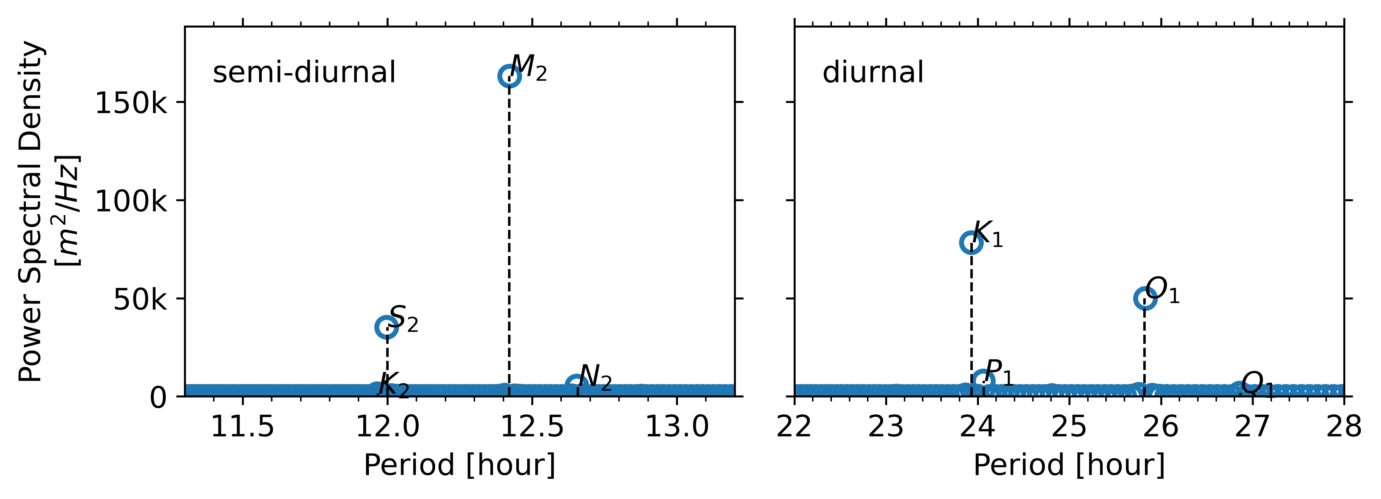
pysolid.plot_power_spectral_density4tides(tide_u, sample_spacing=step_sec)

2.2 Grid Mode [nbviewer]
import datetime as dt
import numpy as np
import pysolid

# prepare inputs
dt_obj = dt.datetime(2020, 12, 25, 14, 7, 44)
atr = {
    'LENGTH' : 500,                # number of rows
    'WIDTH'  : 450,                # number of columns
    'X_FIRST': -126,               # min longitude in degree (upper left corner of the upper left pixel)
    'Y_FIRST': 43,                 # max laitude   in degree (upper left corner of the upper left pixel)
    'X_STEP' :  0.000925926 * 30,  # output resolution in degree
    'Y_STEP' : -0.000925926 * 30,  # output resolution in degree
}

# compute SET via pysolid
(tide_e,
 tide_n,
 tide_u) = pysolid.calc_solid_earth_tides_grid(dt_obj, atr,
                                               display=False,
                                               verbose=True)

# project SET from ENU to radar line-of-sight (LOS) direction with positive for motion towards satellite
inc_angle  =   34.0 / 180. * np.pi  # radian, typical value for Sentinel-1
head_angle = -168.0 / 180. * np.pi  # radian, typical value for Sentinel-1 desc track
tide_los = (  tide_e * np.sin(inc_angle) * np.cos(head_angle) * -1
            + tide_n * np.sin(inc_angle) * np.sin(head_angle)
            + tide_u * np.cos(inc_angle))

- Milbert, D. (2018), solid: Solid Earth Tide, Available: http://geodesyworld.github.io/SOFTS/solid.htm, Accessd on: 2020-09-06.
- Fattahi, H., Yunjun, Z., Pi, X., Agram, P.S., Rosen, P., and Aoki, Y. (2020), Absolute geolocation of SAR Big-Data: The first step for operational InSAR time-series analysis, AGU Fall Meeting 2020, 1-17 Dec 2020.
- Petit, G., and Luzum, B. (2010), IERS Conventions (2010) (IERS Technical Note No. 36) 179 pp., International Earth Rotation And Reference Systems Service (IERS), Frankfurt, Germany. [Code].